To begin I flew from Happy Valley-Goose Bay to Blanc Sablon. The plane was actually bigger than I thought it might have been, but I learned it was because that same plane was continuing on to St. Anthony's and then to St. John's. Not too many people on the initial leg to Blanc Sablon however, most people got on in Blanc Sablon and St. Anthony's for the flight to St. John's. Although the Blanc Sablon airport is actually in Quebec, it's only a few kilometres drive and I was back in Labrador, ready to drive the coastal road.
The Churchill River - and to the right you can see the Trans-Labrador Highway that I came across
Good thing my suitcase is fairly unique - not sure if I could have found it otherwise
In addition to having the airport, Blanc Sablon is also where the ferry from St. Barbe in Newfoundland comes into. The ferry wasn't in port at the time that I arrived, but I was able to see it en route, out in the Strait of Belle Isle.
And in just a couple of kilometres I was back in Labrador again
Labrador's Coastal Drive, along the south coast of Labrador, is very different from the north coast. Here the cliffs are rugged, there are fast moving rivers, and your journey along this coast takes you through many places established as permanent fishing communities in the early 1800s. For the most part, the inland terrain is very wooded as opposed to the north coast with its sub-arctic climate and tundra which dominates the landscape there.
Labrador is just across the Strait of Belle Isle from Newfoundland's Great Northern Peninsula. On a clear day it is visible across the 17.6km wide channel that funnels the icy Labrador current into the Gulf of St. Lawrence. Southern Labrador is the traditional home of the summer fishermen who first travelled from the Island of Newfoundland to the lucrative fishing grounds off its coast centuries ago. Today this area is inhabited by the descendants of those first summer fishermen.
The first community you come to in Labrador is L'Anse au Clair (population approx. 200), just 5kms from Blanc Sablon. L'Anse au Clair was first established by French fishing interests in the early 1700s. Shortly after the Quebec-Labrador border dispute in 1825, Newfoundlanders and people from the south of England also began settling in L'Anse au Clair. The original name of the community was Anse St. Clair, named after one of the first merchants to establish here, whose surname was St. Clair.
L'Anse au Clair has one of the nicest sandy beaches along this coast, and a beautiful walking trail takes you to the Jersey Rooms, a site with foundations of buildings and stone walkways that were part of an 18th century fishing enterprise.
Since the early 1500s, Europeans were coming to this coastal area seasonally to fish and hunt whales and seals. Originally part of New France, France's right to fish along the Labrador coast ended in 1763. The following decades saw the arrival of new mercantile interests. English and Jersey merchants established cod fishing stations all along the coast. In the early 19th century, families began to settle permanently in the area, including the Dumaresq family from the Channel Islands, who settled in L'Anse au Cotard. The Dumaresq family are the "grandparents" of L'Anse au Clair and many of their descendants still live in the community.
Yup - that's the ferry from Newfoundland you can see in the distance
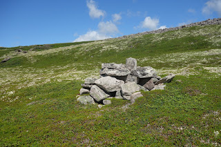
Discovered by archaeologist in 1986, the early Jersey settlement at L'Anse au Cotard was the focus of archaeological excavations in 2004. Three stone structures were identified at the site, which is still above ground.
Wireless messages for the Labrador Straits were received at Point Amour (more on this place in another blog post) then re-transmitted along the "land line" which connected all the other communities. Each community had a telegraph operator to receive the messages. In the 50s and 60s the lines were used for telephones as well. The messages were still received on the wireless at Point Amour and then telephoned to the operators in the communities. Individual telephones were introduced in the 1960s. People often followed the "pole path" to walk between communities, and evidence of this "pole path" can still be seen between L'Anse au Clair and L'Anse au Cotard.


No comments:
Post a Comment